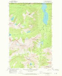
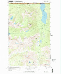
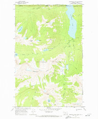
1968 Map of Porcupine Ridge
USGS Topo · Published 1971About this map
Waterton Lakes National Park and Glacier National Park meet at the international Canada United States border, showcasing a landscape of high-altitude lakes and dramatic crests. The map captures the remote backcountry infrastructure of the late 1960s, including the Waterton Ranger Sta and various remote outposts like the Boundary Warden Cabin and Patrol Cabin. Deep in the Waterton Valley, the Waterton River flows through the Kootenai Lakes before reaching the southern tip of Waterton Lake. High-elevation landmarks such as Shaheeya Peak and Campbell Mountain overlook narrow corridors like the Boulder Pass Trail. This document preserves the exact placement of early park amenities, from Shelter Cabins to the Porcupine Lookout, reflecting the era's foot-and-horse trail network before modern developments.
Find a feature on this map
43 named features on this map. Tap any name to fly to it.
Don’t see what you’re looking for? This feature index may not catch every label — zoom into the map to look around manually.
Map Details
Editions of this 1968 Porcupine Ridge Map
3 editions found
Other maps of this area

1904 · Chief Mountain
USGS Topo · 1:125,000

1906 · Kintla Lakes
USGS Topo · 1:125,000

1938 · Chief Mountain
USGS Topo · 1:125,000

1938 · Kintla Lakes
USGS Topo · 1:125,000

1957 · Kalispell
USGS Topo · 1:250,000

1960 · Kalispell
USGS Topo · 1:250,000

1960 · Cut Bank
USGS Topo · 1:250,000

1961 · Kalispell
USGS Topo · 1:250,000

1963 · Cut Bank
USGS Topo · 1:250,000

1964 · Cut Bank
USGS Topo · 1:250,000