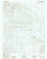
1986 Map of Porcupine Wash
USGS Topo · Published 1987About this map
Hexie Mountains and the Pinto Basin dominate this mid-1980s topographic study of the High Desert interior. The landscape is defined by its arid drainage network, characterized by extensive dry beds like Porcupine Wash and Smoke Tree Wash that cut through the surrounding ranges. This era of mapping documents the desert as a managed wilderness, showing the boundaries between the Joshua Tree National Monument and the Joshua Tree Wilderness.
Find a feature on this map
20 named features on this map. Tap any name to fly to it.
Don’t see what you’re looking for? This feature index may not catch every label — zoom into the map to look around manually.
Map Details
Editions of this 1986 Porcupine Wash Map
This is the sole edition of this map. No revisions or reprints were ever made.
Other maps of this area

1940 · Cottonwood Spring
USGS Topo · 1:62,500

1940 · Canyon Spring
USGS Topo · 1:62,500

1943 · Canyon Spring
USGS Topo · 1:62,500

1943 · Pinkham Well
USGS Topo · 1:62,500

1944 · Cottonwood Spring
USGS Topo · 1:62,500

1944 · Pinkham Well
USGS Topo · 1:62,500

1944 · Eagle Tank
USGS Topo · 1:62,500

1954 · Salton Sea
USGS Topo · 1:250,000

1955 · Salton Sea
USGS Topo · 1:250,000
1958 · Cottonwood Spring
USGS Topo · 1:62,500