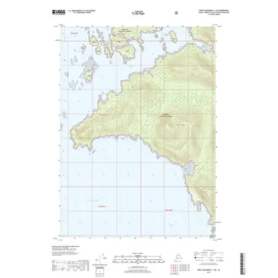
2017 Map of Port Alexander C-1 SW
USGS Topo · Published 2017About this map
Tongass National Forest encompasses the coastal island terrain of this 2017 survey, where the temperate rainforest meets the eastern edge of the Gulf of Alaska. The landscape is defined by its convoluted coastline, punctuated by the prominent westward reach of Point Ellis. To the north, the protected waters of the Bay of Pillars are shielded by a cluster of small offshore islands and reefs, while the southern reaches open into Tebenkof Bay. Inland, the drainage of Kwatahein Cr carves through the heavily contoured ridges, illustrating the complex hydrology of the Alexander Archipelago. This map provides a clear record of these maritime boundaries and topographic elevations before more recent shifts in glacial or sea-level data were recorded.
Find a feature on this map
13 named features on this map. Tap any name to fly to it.
Don’t see what you’re looking for? This feature index may not catch every label — zoom into the map to look around manually.
Map Details
Editions of this 2017 Port Alexander C-1 SW Map
This is the sole edition of this map. No revisions or reprints were ever made.
Other maps of this area

1948 · Port Alexander C-1
USGS Topo · 1:63,360

1948 · Port Alexander B-1
USGS Topo · 1:63,360

1948 · Port Alexander B-2
USGS Topo · 1:63,360

1951 · Port Alexander C-2
USGS Topo · 1:63,360

1951 · Port Alexander
USGS Topo · 1:250,000

1951 · Port Alexander B-2
USGS Topo · 1:63,360

1951 · Port Alexander C-1
USGS Topo · 1:63,360

1952 · Port Alexander
USGS Topo · 1:250,000
1953 · Port Alexander B-1
USGS Topo · 1:63,360

1964 · Port Alexander
USGS Topo · 1:250,000