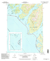
1994 Map of Port Alexander C-4
USGS Topo · Published 1998About this map
Baranof Island's intricate Pacific shoreline dominates this mid-1990s topographic record, detailing a landscape defined by deep fjords and isolated island clusters. Much of the region is protected as part of the South Baranof Wilderness and Tongass National Forest, showing an environment with no established roads or trails. The map highlights the complex maritime geography of the City and Borough of Sitka, including the narrow passages of Rakof Channel and Walker Channel.
Find a feature on this map
40 named features on this map. Tap any name to fly to it.
Don’t see what you’re looking for? This feature index may not catch every label — zoom into the map to look around manually.
Map Details
Editions of this 1994 Port Alexander C-4 Map
3 editions found

Other maps of this area

1951 · Port Alexander D-5
USGS Topo · 1:63,360

1951 · Port Alexander C-4
USGS Topo · 1:63,360

1951 · Port Alexander D-4
USGS Topo · 1:63,360

1951 · Port Alexander B-3 and B-4
USGS Topo · 1:63,360

1951 · Port Alexander C-3
USGS Topo · 1:63,360

1951 · Port Alexander D-3
USGS Topo · 1:63,360

1951 · Port Alexander
USGS Topo · 1:250,000

1952 · Port Alexander
USGS Topo · 1:250,000

1964 · Port Alexander
USGS Topo · 1:250,000

1994 · Port Alexander C-3
USGS Topo · 1:63,360