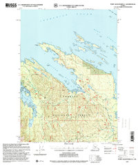
1997 Map of Port Alexander D-1
USGS Topo · Published 2000About this map
Saginaw Bay and the northern reaches of Kuiu Island dominate this coastal survey, where the rugged topography of the Tongass National Forest meets the waters of Frederick Sound. This revision, updated in the late 1990s, captures a landscape defined by its marine resources and wilderness character. The presence of the Pipeline Cannery (Aband) on the northern shore of the bay points to the region's commercial fishing history, while the Fishpass (FS) reflects modern conservation efforts within the forest. Geologic and maritime history are etched into the coastline at Fossil Bluffs and Cornwallis Point, while the protected waters of Security Bay State Marine Park offer a glimpse into the preserved maritime environment. The intricate archipelago of the Keku Islands and the tidal reaches of Kadake Creek further illustrate the complex interaction between the Alexander Archipelago's high-relief interior and the Keku Strait.
Find a feature on this map
25 named features on this map. Tap any name to fly to it.
Don’t see what you’re looking for? This feature index may not catch every label — zoom into the map to look around manually.
Map Details
Editions of this 1997 Port Alexander D-1 Map
This is the sole edition of this map. No revisions or reprints were ever made.
Other maps of this area

1948 · Sitka A-2
USGS Topo · 1:63,360

1948 · Port Alexander C-1
USGS Topo · 1:63,360

1948 · Sumdum A-6
USGS Topo · 1:63,360

1948 · Petersburg D-6
USGS Topo · 1:63,360

1948 · Port Alexander D-1
USGS Topo · 1:63,360

1948 · Petersburg C-6
USGS Topo · 1:63,360

1948 · Sitka A-1
USGS Topo · 1:63,360

1951 · Sitka
USGS Topo · 1:250,000

1951 · Port Alexander C-2
USGS Topo · 1:63,360

1951 · Port Alexander
USGS Topo · 1:250,000