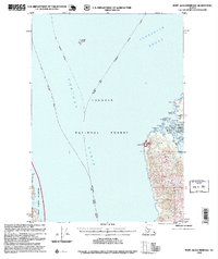
1995 Map of Port Alexander D-2
USGS Topo · Published 1999About this map
Tongass National Forest encompasses the vast maritime landscape of this 1995 revision, where the waters of Chatham Strait and Frederick Sound converge. The topography centers on the northern tip of Kuiu Island and a portion of eastern Baranof Island, highlighting the complex coastline of Security Bay. This area is defined by its maritime navigation and conservation history, featuring the Lighthouse Reserve at Kingsmill Point and the protected waters within Security Bay State Marine Park. Small Cabin sites and localized naming, such as Christmas Island and Paralysis Point, suggest a history of seasonal use and maritime hazards. To the west, the South Baranof Wilderness borders the deep waters of Hoggatt Bay, reflecting the region's transition into more protected environmental management by the late 20th century.
Find a feature on this map
34 named features on this map. Tap any name to fly to it.
Don’t see what you’re looking for? This feature index may not catch every label — zoom into the map to look around manually.
Map Details
Editions of this 1995 Port Alexander D-2 Map
This is the sole edition of this map. No revisions or reprints were ever made.
Other maps of this area

1948 · Sitka A-3
USGS Topo · 1:63,360

1948 · Sitka A-2
USGS Topo · 1:63,360

1948 · Port Alexander C-1
USGS Topo · 1:63,360

1948 · Port Alexander D-1
USGS Topo · 1:63,360

1948 · Sitka A-1
USGS Topo · 1:63,360

1951 · Sitka
USGS Topo · 1:250,000

1951 · Port Alexander C-2
USGS Topo · 1:63,360

1951 · Port Alexander C-3
USGS Topo · 1:63,360

1951 · Port Alexander D-3
USGS Topo · 1:63,360

1951 · Port Alexander
USGS Topo · 1:250,000