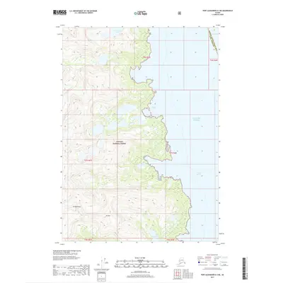
2017 Map of Port Alexander D-3 NE
USGS Topo · Published 2017About this map
Tongass National Forest covers the entirety of this coastal Alaskan landscape, where the island terrain rises sharply from the sea. The topography is defined by significant elevations such as Mt Radamaker and Mt Race, which anchor the interior heights. Along the eastern shoreline, the intricate boundary between land and water is marked by Nelson Bay and the broad reach of the Gulf of Alaska and Chatham Strait. This 2017 survey illustrates a largely untouched wilderness characterized by alpine lakes and glacial-carved peaks. Freshwater systems are tucked high into the mountains, including Four Falls Lake in the north and the Wakefield Lakes cluster to the south. The map documents the specific administrative divide between the Hoonah-Angoon Census Area and Sitka Borough, providing a precise look at these remote jurisdictional boundaries.
Find a feature on this map
15 named features on this map. Tap any name to fly to it.
Don’t see what you’re looking for? This feature index may not catch every label — zoom into the map to look around manually.
Map Details
Editions of this 2017 Port Alexander D-3 NE Map
This is the sole edition of this map. No revisions or reprints were ever made.
Other maps of this area

1948 · Sitka A-3
USGS Topo · 1:63,360

1948 · Sitka A-2
USGS Topo · 1:63,360

1951 · Sitka
USGS Topo · 1:250,000

1951 · Port Alexander D-3
USGS Topo · 1:63,360

1951 · Port Alexander
USGS Topo · 1:250,000

1951 · Port Alexander D-2
USGS Topo · 1:63,360

1951 · Sitka A-2
USGS Topo · 1:63,360
1951 · Sitka A-3
USGS Topo · 1:63,360

1952 · Port Alexander
USGS Topo · 1:250,000

1952 · Sitka
USGS Topo · 1:250,000