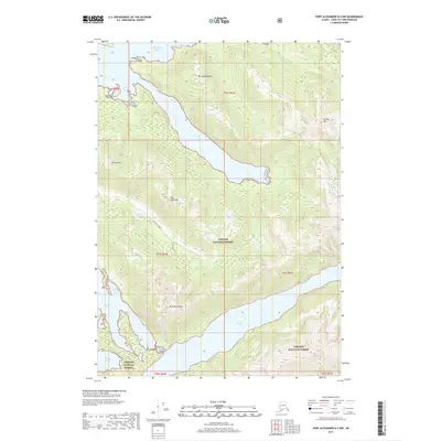
2017 Map of Port Alexander D-4 NW
USGS Topo · Published 2017About this map
Tongass National Forest dominates this coastal landscape on Baranof Island, where the steep topography of the Alexander Archipelago meets the complex waterways of Sitka Sound. The map reveals a heavily glaciated terrain defined by dramatic peaks such as The Pyramids and Mt Dranishnikof, which tower over the deep fjord of Deep Inlet. This 2017 data highlights the intricate relationship between the mountain runoff and the coastal ecosystem, tracing the paths of the Dranishnikov River and Kizhuchia Creek as they feed into protected waters like Redoubt Lake and Redoubt Bay. Access to this wilderness is limited, with the Kizhuchia Creek Road and Kizhuchia Spur N providing rare terrestrial corridors through the dense forest and around the jagged shoreline of Kidney Cove and Sandy Cove.
Find a feature on this map
26 named features on this map. Tap any name to fly to it.
Don’t see what you’re looking for? This feature index may not catch every label — zoom into the map to look around manually.
Map Details
Editions of this 2017 Port Alexander D-4 NW Map
This is the sole edition of this map. No revisions or reprints were ever made.
Other maps of this area

1948 · Sitka A-5
USGS Topo · 1:63,360

1951 · Port Alexander D-5
USGS Topo · 1:63,360

1951 · Sitka
USGS Topo · 1:250,000

1951 · Port Alexander D-4
USGS Topo · 1:63,360

1951 · Port Alexander
USGS Topo · 1:250,000

1951 · Sitka A-4
USGS Topo · 1:63,360

1951 · Sitka A-5
USGS Topo · 1:63,360

1952 · Port Alexander
USGS Topo · 1:250,000

1952 · Sitka
USGS Topo · 1:250,000

1954 · Sitka A-4
USGS Topo · 1:63,360