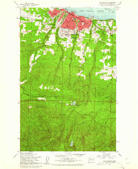
1961 Map of Port Angeles
USGS Topo · Published 1961About this map
Port Angeles serves as the focal point of this 1961 survey, where the urban grid meets the northern edge of the Olympic National Park. The city's northern waterfront along the Port Angeles Harbor and Juan de Fuca Strait features the Milwaukee Road railroad lines and infrastructure like the Weather Bureau Tower. Local institutions including the Queen of Angels Sch and Port Angeles High School are shown alongside public landmarks such as the Olympic Memorial Hospital and the County Airport.
Find a feature on this map
56 named features on this map. Tap any name to fly to it.
Don’t see what you’re looking for? This feature index may not catch every label — zoom into the map to look around manually.
Map Details
Editions of this 1961 Port Angeles Map
3 editions found
Other maps of this area

1918 · Port Angeles
USGS Topo · 1:62,500

1919 · Port Crescent
USGS Topo · 1:62,500

1935 · Mount Olympus
USGS Topo · 1:62,500

1938 · Mt Constance
USGS Topo · 1:125,000

1941 · Port Angeles
USGS Topo · 1:62,500

1942 · Mount Olympus
USGS Topo · 1:62,500

1944 · Mt. Angeles
USGS Topo · 1:62,500

1946 · Mt. Angeles
USGS Topo · 1:62,500

1950 · Elwha
USGS Topo · 1:24,000

1950 · Ediz Hook
USGS Topo · 1:24,000