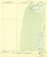
1946 Map of Port Arthur NE
USGS Topo · Published 1946About this map
The coastal marshlands of Cameron Parish and the Texas-Louisiana border define this mid-century topographic record. Centered on the eastern expanse of Sabine Lake, the map documents a landscape where the natural hydrology of East Pass and the Sabine River meets industrial and recreational outposts. Notable camps such as Rosenthal-Brown Camp and Willow Camp are situated along the interior waterways, reflecting the region's historical reliance on seasonal or industrial settlements.
Find a feature on this map
16 named features on this map. Tap any name to fly to it.
Don’t see what you’re looking for? This feature index may not catch every label — zoom into the map to look around manually.
Map Details
Editions of this 1946 Port Arthur NE Map
This is the sole edition of this map. No revisions or reprints were ever made.
Other maps of this area

1926 · Terry
USGS Topo · 1:24,000

1932 · Orange
USGS Topo · 1:62,500

1932 · Port Arthur NE
USGS Topo · 1:31,680

1934 · Johnsons Bayou
USGS Topo · 1:24,000

1934 · Greens Bayou
USGS Topo · 1:24,000

1935 · Greens Bayou
USGS Topo · 1:31,680

1935 · Johnsons Bayou
USGS Topo · 1:31,680

1943 · West of Johnson Bayou
USGS Topo · 1:24,000

1943 · West of Greens Bayou
USGS Topo · 1:24,000

1943 · Orangefield
USGS Topo · 1:24,000