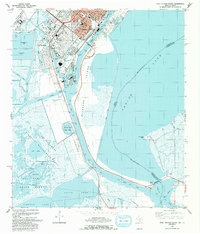
1993 Map of Port Arthur South
USGS Topo · Published 1993About this map
The industrial shoreline of Port Arthur is defined by a complex network of waterways, including the Port Arthur Ship Canal and the Gulf Intracoastal Waterway. This 1993 edition, based on earlier surveys and updated aerial photography, illustrates the heavy industrialization of the Texas coast with extensive refinery sites, tank farms, and industrial waste ponds situated near the city's residential and civic center. Notable local institutions such as Lincoln High Sch and Booker T Washington Sch serve the community, while green spaces like Carver Terrace Park and Lincoln Park provide contrast to the surrounding docks and basins.
Find a feature on this map
53 named features on this map. Tap any name to fly to it.
Don’t see what you’re looking for? This feature index may not catch every label — zoom into the map to look around manually.
Map Details
Editions of this 1993 Port Arthur South Map
This is the sole edition of this map. No revisions or reprints were ever made.
Other maps of this area

1932 · Sabine Pass NE
USGS Topo · 1:31,680

1932 · Port Arthur NE
USGS Topo · 1:31,680

1943 · West of Johnson Bayou
USGS Topo · 1:24,000

1943 · West of Greens Bayou
USGS Topo · 1:24,000

1943 · Port Arthur North
USGS Topo · 1:24,000

1943 · Port Arthur South
USGS Topo · 1:24,000

1944 · Sabine Pass
USGS Topo · 1:31,680

1944 · Texas Point
USGS Topo · 1:31,680
1946 · Port Arthur NE
USGS Topo · 1:31,680
1946 · Sabine Pass NE
USGS Topo · 1:31,680