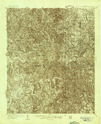
1935 Map of Port Birmingham
USGS Topo · Published 1935About this map
The Mulberry Fork Black Warrior River carves a deep, winding path through this industrial landscape of the mid-1930s, where coal mining and timber production define the terrain. Heavy industry is anchored by the Alabama Power Company and major extraction sites such as the Gorgas Mine, Black Creek Shaft, and Barney Mine. These operations are supported by a complex network of company housing and settlements, including Pennsylvania Camp, Short Camp, and High Level.
Find a feature on this map
92 named features on this map. Tap any name to fly to it.
Don’t see what you’re looking for? This feature index may not catch every label — zoom into the map to look around manually.
Map Details
Editions of this 1935 Port Birmingham Map
This is the sole edition of this map. No revisions or reprints were ever made.
Other maps of this area

1889 · Birmingham
USGS Topo · 1:125,000

1890 · Bessemer
USGS Topo · 1:125,000

1892 · Birmingham
USGS Topo · 1:125,000

1892 · Bessemer
USGS Topo · 1:125,000

1893 · Jasper
USGS Topo · 1:125,000

1895 · Birmingham
USGS Topo · 1:125,000

1899 · Brookwood
USGS Topo · 1:125,000
1904 · Birmingham Coal District
USGS Topo · 1:62,500
1905 · Bessemer Iron District
USGS Topo · 1:62,500
1906 · Birmingham Special
USGS Topo · 1:62,500