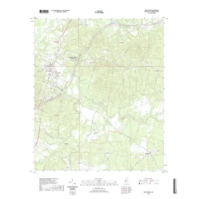
2020 Map of Port Gibson
USGS Topo · Published 2020About this map
Port Gibson stands as the historic center of this Claiborne County landscape, where the Claiborne County Courthouse and several significant burial grounds, including Wintergreen Cem and the Port Gibson Catholic Cem, mark the town's enduring heritage. The terrain is defined by the winding course of Bayou Pierre and its tributaries, such as Little Bayou Pierre and Bakers Creek. The modern alignment of the Natchez Trace Parkway cuts across the region, roughly paralleling the older routes of the Natchez Trace Pkwy and Old 61 Hwy. To the southeast, the small settlements of Gordon and Pattison are connected by a network of rural roads like Pattison Tillman Rd and Lacache Rd, reflecting the area's agricultural past and the importance of creek-side family landmarks like Douglass Cem and Wilson Cem.
Find a feature on this map
75 named features on this map. Tap any name to fly to it.
Don’t see what you’re looking for? This feature index may not catch every label — zoom into the map to look around manually.
Map Details
Editions of this 2020 Port Gibson Map
This is the sole edition of this map. No revisions or reprints were ever made.
Other maps of this area

1939 · Yokena
USGS Topo · 1:62,500

1939 · Lorman
USGS Topo · 1:62,500

1953 · Natchez
USGS Topo · 1:250,000

1955 · Jackson
USGS Topo · 1:250,000

1956 · Natchez
USGS Topo · 1:250,000

1958 · St. Joseph
USGS Topo · 1:62,500

1959 · Natchez
USGS Topo · 1:250,000

1961 · Jackson
USGS Topo · 1:250,000

1962 · Jackson
USGS Topo · 1:250,000

1963 · Carlisle
USGS Topo · 1:24,000