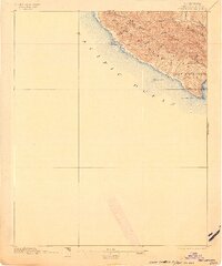
1897 Map of Port Harford
USGS Topo · Published 1903About this map
The Pecho Luis Range dominates this late-nineteenth-century coastal survey, where the rugged terrain of the San Miguelito land grant meets the Pacific. At the southern tip of this coastal ridge lies Port Harford, a vital maritime gateway for the region. The map highlights the navigational infrastructure of the era, including the L.H. at Pt. San Luis and several prominent offshore landmarks like Pecho Rock and Whaler Id.. Numerous canyons, such as Diablo Canyon and See Canyon, cut through the hills, illustrating the natural drainage patterns that shaped early access to the interior. The presence of Mine Canyon suggests the early industrial interests that shared this landscape with traditional ranching and maritime commerce. This survey captures the transition of the San Luis Obispo coast from a series of isolated canyons into a structured maritime district.
Find a feature on this map
24 named features on this map. Tap any name to fly to it.
Don’t see what you’re looking for? This feature index may not catch every label — zoom into the map to look around manually.
Map Details
Editions of this 1897 Port Harford Map
3 editions found
Other maps of this area

1897 · Port Harford
USGS Topo · 1:62,500

1897 · San Luis Obispo
USGS Topo · 1:62,500

1897 · Cayucos
USGS Topo · 1:62,500

1897 · Arroyo Grande
USGS Topo · 1:62,500

1900 · San Luis
USGS Topo · 1:125,000

1905 · Guadalupe
USGS Topo · 1:125,000

1937 · Cayucos
USGS Topo · 1:62,500

1941 · Port San Luis
USGS Topo · 1:62,500

1942 · Guadalupe
USGS Topo · 1:125,000

1942 · San Luis Obispo
USGS Topo · 1:62,500