
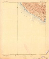
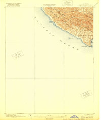
1897 Map of Port Harford
USGS Topo · Published 1897About this map
Port Harford serves as the focal point of this coastal survey, where the terrestrial landscape of the Pecho Mountain Range meets the shelf of the Pacific Ocean. The topography is defined by a succession of steep drainages, including Wild Cherry Canyon and Mine Canyon, which carve through the high ground of Saddle Peak and Bald Knob. Along the shoreline, maritime navigation is highlighted by landmarks such as Pt. San Luis, Whaler Id., and Tunnel Pt., while the presence of San Luis Hill overlooking the harbor suggests the strategic importance of this cove before modern coastal development. The inland portion of the San Miguelito land grant shows a network of canyons like Diablo Canyon and Rude Canyon, illustrating a rugged transition from mountain peaks to the sea.
Find a feature on this map
23 named features on this map. Tap any name to fly to it.
Don’t see what you’re looking for? This feature index may not catch every label — zoom into the map to look around manually.
Map Details
Editions of this 1897 Port Harford Map
3 editions found
Other maps of this area

1897 · San Luis Obispo
USGS Topo · 1:62,500

1897 · Cayucos
USGS Topo · 1:62,500

1897 · Arroyo Grande
USGS Topo · 1:62,500

1900 · San Luis
USGS Topo · 1:125,000

1905 · Guadalupe
USGS Topo · 1:125,000

1937 · Cayucos
USGS Topo · 1:62,500

1941 · Port San Luis
USGS Topo · 1:62,500

1942 · Guadalupe
USGS Topo · 1:125,000

1942 · San Luis Obispo
USGS Topo · 1:62,500

1942 · Arroyo Grande
USGS Topo · 1:62,500