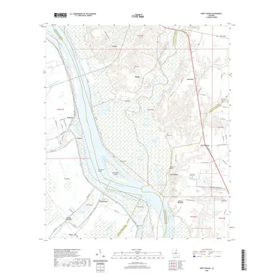
2020 Map of Port Hudson
USGS Topo · Published 2020About this map
The Mississippi River creates a dramatic curve at Fancy Point as it flows south toward the confluence of Thompson Creek. This complex riparian landscape is defined by its shifting watercourses and wetland systems, including Grand Lake, Mitchell Lake, and Alligator Bayou. On the eastern bluffs, the importance of this region's military and civic history is preserved at the Port Hudson National Cem and the newer Louisiana National Cem.
Find a feature on this map
93 named features on this map. Tap any name to fly to it.
Don’t see what you’re looking for? This feature index may not catch every label — zoom into the map to look around manually.
Map Details
Editions of this 2020 Port Hudson Map
This is the sole edition of this map. No revisions or reprints were ever made.
Other maps of this area

1906 · Bayou Sara
USGS Topo · 1:125,000

1939 · St. Francisville
USGS Topo · 1:62,500

1939 · Zachary
USGS Topo · 1:62,500

1945 · Jackson
USGS Topo · 1:31,680

1953 · New Roads
USGS Topo · 1:24,000

1954 · Zachary
USGS Topo · 1:24,000

1954 · Port Hudson
USGS Topo · 1:24,000

1954 · Walls
USGS Topo · 1:24,000

1954 · Elm Park
USGS Topo · 1:24,000
1954 · Scotlandville
USGS Topo · 1:24,000