
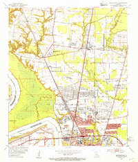
1954 Map of Port Hudson
USGS Topo · Published 1955About this map
Mississippi River river traffic and the complex hydrology of the Louisiana lowlands dominate this mid-century survey. The landscape is defined by its relation to the water, where a system of Levees and a spoil bank protect the fertile ground of Pointe Coupee Parish from the shifting Fausse River Cut-Off. A dense network of landings, including Waterloo Landing, Anchor Landing, and Grand Bay Landing, highlights the era's reliance on riverborne commerce and the transportation of goods from the interior.
Find a feature on this map
67 named features on this map. Tap any name to fly to it.
Don’t see what you’re looking for? This feature index may not catch every label — zoom into the map to look around manually.
Map Details
Editions of this 1954 Port Hudson Map
This is the sole edition of this map. No revisions or reprints were ever made.
Other maps of this area

1906 · Bayou Sara
USGS Topo · 1:125,000

1939 · St. Francisville
USGS Topo · 1:62,500

1939 · Zachary
USGS Topo · 1:62,500

1945 · Jackson
USGS Topo · 1:31,680

1953 · New Roads
USGS Topo · 1:24,000

1954 · Zachary
USGS Topo · 1:24,000

1954 · Walls
USGS Topo · 1:24,000

1954 · Elm Park
USGS Topo · 1:24,000
1954 · Scotlandville
USGS Topo · 1:24,000

1954 · Erwinville
USGS Topo · 1:24,000