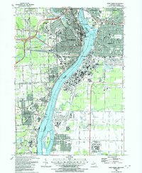
1991 Map of Port Huron
USGS Topo · Published 1992About this map
The St Clair River serves as the international border between Port Huron, Michigan, and Sarnia, Ontario, in this detailed look at a bustling border crossing in the early 1990s. The landscape is defined by the heavy industrial and transportation infrastructure required for trade between the United States and Canada, notably the St Clair Tunnel and various sewage and industrial waste disposal facilities. In Port Huron, the residential fabric is dense with institutional landmarks like Mercy Hospital and St Stephen Ch, while the Canadian side features the distinct riverside settlements of Corunna and Froomfield. The map reveals the era's balance of industry and community, showing numerous schools such as Michigamme Sch and Chippewa Jr High Sch alongside the sprawling rail networks and shoreline waterworks that powered the regional economy.
Find a feature on this map
69 named features on this map. Tap any name to fly to it.
Don’t see what you’re looking for? This feature index may not catch every label — zoom into the map to look around manually.
Map Details
Editions of this 1991 Port Huron Map
This is the sole edition of this map. No revisions or reprints were ever made.
Other maps of this area

1912 · Port Huron
USGS Topo · 1:62,500

1928 · Hicky
USGS Topo · 1:62,500

1929 · Port Huron
USGS Topo · 1:62,500

1936 · St. Clair
USGS Topo · 1:31,680

1936 · Rattle Run
USGS Topo · 1:31,680

1939 · Port Huron
USGS Topo · 1:24,000

1939 · St. Clair
USGS Topo · 1:24,000

1939 · Smiths Creek
USGS Topo · 1:24,000

1942 · Rattle Run
USGS Topo · 1:24,000
1949 · Port Huron
USGS Topo · 1:24,000