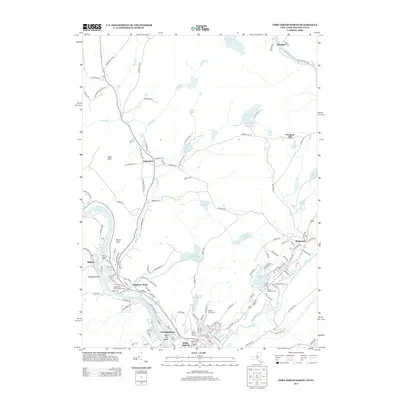
2013 Map of Port Jervis North
USGS Topo · Published 2013About this map
Port Jervis sits at the confluence of several major waterways and historical settlements where New York, New Jersey, and Pennsylvania converge. The Delaware River serves as the primary boundary to the west, while the Neversink River carves through the southern portion of the quadrangle. This 2013 survey documents a landscape defined by its mix of industrial centers and recreational retreats. Near the riverside, local history is preserved at the Agudath Achim Cem and within residential clusters like Germantown and Sparrow Bush.
Find a feature on this map
140 named features on this map. Tap any name to fly to it.
Don’t see what you’re looking for? This feature index may not catch every label — zoom into the map to look around manually.
Map Details
Editions of this 2013 Port Jervis North Map
This is the sole edition of this map. No revisions or reprints were ever made.
Other maps of this area

1906 · Port Jervis
USGS Topo · 1:62,500

1908 · Port Jervis
USGS Topo · 1:62,500

1909 · Monticello
USGS Topo · 1:62,500

1911 · Monticello
USGS Topo · 1:62,500

1913 · Milford
USGS Topo · 1:62,500

1915 · Milford
USGS Topo · 1:62,500

1922 · White Lake
USGS Topo · 1:62,500

1942 · White Lake
USGS Topo · 1:62,500

1942 · Port Jervis North
USGS Topo · 1:24,000
1942 · Otisville
USGS Topo · 1:24,000