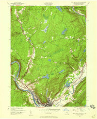
1942 Map of Port Jervis North
USGS Topo · Published 1959About this map
Port Jervis sits at a critical geographic junction where the Delaware River meets the Neversink River, forming a hub of transportation and settlement in the early 1940s. The landscape is defined by the steep transition from the river valley into the Shawangunk Mountains, most notably at the Hawks Nest overlook. This era shows the city and surrounding townships of Deerpark and Westfall serviced by significant rail infrastructure, including the Erie and the New York Ontario and Western lines. Local commerce and community life are grounded in landmarks like the Huguenot Airport, State Police Station, and rural educational outposts such as Huguenot Sch No 2 and Oakland Sch. Beyond the valley floor, the terrain rises toward Quarry Hill and Prospect Hill, punctuated by a series of upland water bodies including Big Pond, Little Pond, and Reservoir No 3.
Find a feature on this map
31 named features on this map. Tap any name to fly to it.
Don’t see what you’re looking for? This feature index may not catch every label — zoom into the map to look around manually.
Map Details
Editions of this 1942 Port Jervis North Map
2 editions found
Other maps of this area

1906 · Port Jervis
USGS Topo · 1:62,500

1908 · Port Jervis
USGS Topo · 1:62,500

1909 · Monticello
USGS Topo · 1:62,500

1911 · Monticello
USGS Topo · 1:62,500

1913 · Milford
USGS Topo · 1:62,500

1915 · Milford
USGS Topo · 1:62,500

1922 · White Lake
USGS Topo · 1:62,500

1942 · White Lake
USGS Topo · 1:62,500

1942 · Port Jervis North
USGS Topo · 1:24,000
1942 · Otisville
USGS Topo · 1:24,000