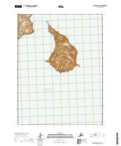
2020 Map of Port Moller A-5 SW
USGS Topo · Published 2020About this map
Poperechnoi Island dominates this maritime survey, rising from the Pacific Ocean with a complex topography of ridges and peaks reaching over 1,500 feet. The island's isolation in the Aleutians East region is starkly illustrated, with no permanent structures or roads indicated on its landmass. To the northwest, a portion of Dolgoi Island is visible, separated from its neighbor by cold subarctic waters. The survey captures these landforms as they appeared in 2020, documenting the precise coastlines and elevation contours that define this uninhabited archipelago. The absence of development highlights the preservation of the natural coastal environment, providing a clean record of these islands for geographers and maritime historians.
Find a feature on this map
9 named features on this map. Tap any name to fly to it.
Don’t see what you’re looking for? This feature index may not catch every label — zoom into the map to look around manually.
Map Details
Editions of this 2020 Port Moller A-5 SW Map
This is the sole edition of this map. No revisions or reprints were ever made.
Other maps of this area

1949 · False Pass
USGS Topo · 1:250,000

1950 · False Pass
USGS Topo · 1:250,000

1953 · Port Moller
USGS Topo · 1:250,000

1963 · Port Moller A-5
USGS Topo · 1:63,360

1963 · Port Moller A-6
USGS Topo · 1:63,360
1963 · False Pass D-0
USGS Topo · 1:63,360

1963 · Simeonof Island
USGS Topo · 1:250,000

1967 · Simeonof Island
USGS Topo · 1:250,000

1988 · Port Moller
USGS Topo · 1:250,000
2020 · False Pass D-0 OE E NW
USGS Topo · 1:25,000