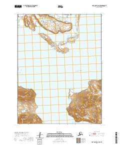
2020 Map of Port Moller A-6 NW
USGS Topo · Published 2020About this map
Volcano Bay and the surrounding coastal reaches of the Alaska Peninsula define this landscape, where tidal waters meet complex shorelines. This 2020 map documents the intricate geography of Dushkin Lagoon and Long John Lagoon, protected inlets that carve into the landmass north of the open Pacific Ocean. The topography is marked by prominent coastal features including Arch Point and Bluff Point, which serve as natural landmarks for navigating these northern waters. Along the southwestern coast, Bear Cape and Bear Bay illustrate the dramatic interface between the sea and the rising terrain. This recent survey provides a precise look at the hydrology and landforms of a sparsely inhabited region of the Aleutians East Borough, recording the exact position of these maritime features for modern researchers.
Find a feature on this map
12 named features on this map. Tap any name to fly to it.
Don’t see what you’re looking for? This feature index may not catch every label — zoom into the map to look around manually.
Map Details
Editions of this 2020 Port Moller A-6 NW Map
This is the sole edition of this map. No revisions or reprints were ever made.
Other maps of this area

1943 · Fort Randall
USGS Topo · 1:250,000

1949 · Fort Randall
USGS Topo · 1:250,000

1950 · Fort Randall
USGS Topo · 1:250,000

1953 · Port Moller
USGS Topo · 1:250,000

1963 · Port Moller A-6
USGS Topo · 1:63,360

1983 · Port Moller B-6
USGS Topo · 1:63,360
1983 · Cold Bay A-1
USGS Topo · 1:63,360
1983 · Cold Bay B-1
USGS Topo · 1:63,360

1988 · Port Moller
USGS Topo · 1:250,000
2020 · Cold Bay A-1 SE
USGS Topo · 1:25,000