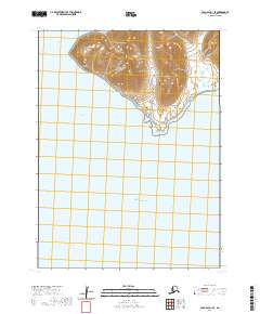
2020 Map of Cold Bay A-1 SE
USGS Topo · Published 2020About this map
Belkofski stands on the rugged coastline of the Alaska Peninsula in this 2020 topographic survey, a location deeply tied to the maritime history of the Aleutians East Borough. The terrain rises sharply from the shore into high, unnamed peaks that dominate the northern half of the quadrangle, while the southern expanse is defined by the open waters of the Pacific Ocean. This coastal orientation highlights the isolation of the settlement, accessible primarily by water via Belkofski Bay. The survey documents the transition from the high-relief interior down to Belkofski Point, providing a contemporary record of the landforms and maritime boundaries in this remote reach of southwest Alaska. Researchers can trace the topography surrounding the village site and the shoreline features that have long dictated travel and subsistence in the region.
Find a feature on this map
10 named features on this map. Tap any name to fly to it.
Don’t see what you’re looking for? This feature index may not catch every label — zoom into the map to look around manually.
Map Details
Editions of this 2020 Cold Bay A-1 SE Map
This is the sole edition of this map. No revisions or reprints were ever made.
Other maps of this area

1943 · Fort Randall
USGS Topo · 1:250,000

1949 · False Pass
USGS Topo · 1:250,000

1949 · Fort Randall
USGS Topo · 1:250,000

1950 · False Pass
USGS Topo · 1:250,000

1950 · Fort Randall
USGS Topo · 1:250,000

1953 · Port Moller
USGS Topo · 1:250,000

1963 · Port Moller A-6
USGS Topo · 1:63,360
1963 · False Pass D-0
USGS Topo · 1:63,360

1963 · False Pass D-1
USGS Topo · 1:63,360
1983 · Cold Bay A-1
USGS Topo · 1:63,360