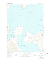
1963 Map of Port Moller B-2
USGS Topo · Published 1983About this map
Sand Point serves as the primary hub on Popof Island in this early 1960s coastal survey, situated between Humboldt Harbor and Mud Bay. The map captures the maritime infrastructure of the Shumagin Islands, featuring a Landing Strip and Radio Towers essential for navigation in these waters. Across the Unga Strait, the larger Unga Island reveals a complex shoreline of inlets and bights, including Coal Harbor and the appropriately named White Bluff. The hydrographic data, compiled from mid-century coastal charts, details the treacherous waters of the Korovin Strait and the numerous small islands such as Korovin Island and Henderson Island that define this maritime landscape.
Find a feature on this map
35 named features on this map. Tap any name to fly to it.
Don’t see what you’re looking for? This feature index may not catch every label — zoom into the map to look around manually.
Map Details
Editions of this 1963 Port Moller B-2 Map
2 editions found
Other maps of this area

1953 · Port Moller
USGS Topo · 1:250,000

1963 · Port Moller A-1
USGS Topo · 1:63,360

1963 · Port Moller A-2
USGS Topo · 1:63,360

1963 · Port Moller B-2
USGS Topo · 1:63,360

1963 · Port Moller C-2
USGS Topo · 1:63,360

1963 · Port Moller B-1
USGS Topo · 1:63,360

1963 · Port Moller C-1
USGS Topo · 1:63,360
1963 · Port Moller A-3
USGS Topo · 1:63,360

1983 · Port Moller B-3
USGS Topo · 1:63,360

1983 · Port Moller C-3
USGS Topo · 1:63,360