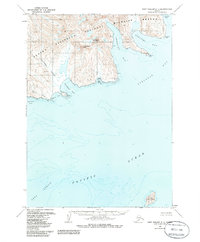
1963 Map of Port Moller C-1
USGS Topo · Published 1985About this map
Alaska Peninsula National Wildlife Refuge dominates the coastline in this 1960s topographic study, where the peninsula's mountainous spine meets the Pacific Ocean. High peaks including Mount Stepo and Chichagof Peak tower over a deeply indented shoreline of bays and coves. The landscape is defined by its maritime exposure, featuring named coastal landmarks like Elephant Point and Blunt Point that provided essential navigation references.
Find a feature on this map
21 named features on this map. Tap any name to fly to it.
Don’t see what you’re looking for? This feature index may not catch every label — zoom into the map to look around manually.
Map Details
Editions of this 1963 Port Moller C-1 Map
2 editions found
Other maps of this area

1951 · Stepovak Bay
USGS Topo · 1:250,000

1953 · Port Moller
USGS Topo · 1:250,000

1963 · Port Moller B-2
USGS Topo · 1:63,360

1963 · Port Moller C-2
USGS Topo · 1:63,360

1963 · Port Moller B-1
USGS Topo · 1:63,360

1963 · Port Moller C-1
USGS Topo · 1:63,360

1963 · Stepovak Bay D-6
USGS Topo · 1:63,360
1963 · Stepovak Bay B-6
USGS Topo · 1:63,360

1963 · Port Moller D-2
USGS Topo · 1:63,360

1963 · Stepovak Bay
USGS Topo · 1:250,000