
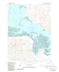
1963 Map of Port Moller D-2
USGS Topo · Published 1967About this map
Port Moller anchors this coastal survey of the Alaska Peninsula, situated at the entrance to a vast tidal estuary where the Hague Channel meets the open water. The landscape is defined by dramatic coastal formations like Moller Spit, which extends northeast toward Entrance Point, and the shifting shoals of Mud and Sand that dominate the interior bay. To the south, the terrain rises sharply into the peaks of Staniukovich Mountain, drained by Coal Creek as it flows through the broad Coal Valley.
Find a feature on this map
21 named features on this map. Tap any name to fly to it.
Don’t see what you’re looking for? This feature index may not catch every label — zoom into the map to look around manually.
Map Details
Editions of this 1963 Port Moller D-2 Map
2 editions found
Other maps of this area

1953 · Port Moller
USGS Topo · 1:250,000

1963 · Port Moller D-3
USGS Topo · 1:63,360

1963 · Port Moller C-2
USGS Topo · 1:63,360

1963 · Port Moller C-1
USGS Topo · 1:63,360

1963 · Chignik A-7
USGS Topo · 1:63,360

1963 · Chignik
USGS Topo · 1:250,000
1963 · Chignik A-8
USGS Topo · 1:63,360
1963 · Port Moller D-1
USGS Topo · 1:63,360

1983 · Port Moller C-3
USGS Topo · 1:63,360

1988 · Port Moller
USGS Topo · 1:250,000