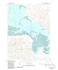
1963 Map of Port Moller D-2
USGS Topo · Published 1985About this map
Port Moller occupies a strategic position on the northern coast of the Alaska Peninsula, where the narrow Moller Spit extends into the waters of Hague Channel. This mid-century survey illustrates a landscape defined by its remote maritime character, with the shoreline transitioning from the sandy reaches of Entrance Point and Harbor Point to the protected flats of Mud Bay. Inland, the terrain rises sharply toward the heights of Staniukovich Mountain, while the lowlands are carved by the Coal Creek Valley and Lawrence Valley.
Find a feature on this map
20 named features on this map. Tap any name to fly to it.
Don’t see what you’re looking for? This feature index may not catch every label — zoom into the map to look around manually.
Map Details
Editions of this 1963 Port Moller D-2 Map
2 editions found
Other maps of this area

1953 · Port Moller
USGS Topo · 1:250,000

1963 · Port Moller D-3
USGS Topo · 1:63,360

1963 · Port Moller C-2
USGS Topo · 1:63,360

1963 · Port Moller C-1
USGS Topo · 1:63,360

1963 · Chignik A-7
USGS Topo · 1:63,360

1963 · Port Moller D-2
USGS Topo · 1:63,360

1963 · Chignik
USGS Topo · 1:250,000
1963 · Chignik A-8
USGS Topo · 1:63,360
1963 · Port Moller D-1
USGS Topo · 1:63,360

1983 · Port Moller C-3
USGS Topo · 1:63,360