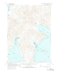
1963 Map of Port Moller C-2
USGS Topo · Published 1984About this map
Balboa Bay and Lefthand Bay anchor the southern coastline of this Alaska Peninsula survey, where the narrow landmass creates a corridor of water and mountain. To the north, the waters of Herendeen Bay reach inland, nearly meeting the southern inlets at Albatross Anchorage. This topography highlights the vital portages used to traverse the peninsula, such as Portage Valley, which connects the Pacific and Bering Sea drainages. Isolated Cabins are noted along the shorelines of Dorenoi Bay and San Diego Bay, suggesting the seasonal or resource-based settlement patterns of the early 1960s. Significant maritime landmarks include Monolith Pt and the sheltering landmass of Guillemot Island, located just off the coast in the Unga Strait. The map also delineates extensive Tidal Flats and numerous unnamed peaks, illustrating the complex transition from glacial valleys to the sea.
Find a feature on this map
27 named features on this map. Tap any name to fly to it.
Don’t see what you’re looking for? This feature index may not catch every label — zoom into the map to look around manually.
Map Details
Editions of this 1963 Port Moller C-2 Map
2 editions found
Other maps of this area

1953 · Port Moller
USGS Topo · 1:250,000

1963 · Port Moller D-3
USGS Topo · 1:63,360

1963 · Port Moller B-2
USGS Topo · 1:63,360

1963 · Port Moller C-2
USGS Topo · 1:63,360

1963 · Port Moller B-1
USGS Topo · 1:63,360

1963 · Port Moller C-1
USGS Topo · 1:63,360

1963 · Port Moller D-2
USGS Topo · 1:63,360
1963 · Port Moller D-1
USGS Topo · 1:63,360

1983 · Port Moller B-3
USGS Topo · 1:63,360

1983 · Port Moller C-3
USGS Topo · 1:63,360