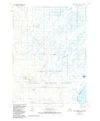
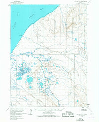
1963 Map of Port Moller C-6
USGS Topo · Published 1985About this map
Alaska Peninsula National Wildlife Refuge dominates this coastal landscape on the southwestern peninsula, where an intricate network of waterways flows toward the Pacific. The topographic survey reveals a wilderness defined by drainage patterns, from the meandering Steelhead Creek and David River in the north to the Caribou River which empties into the tidal flats. Along the southern shore, the protected waters of Pavlof Bay are fed by Chinaman Lagoon and Jackson Lagoon, while the elevation rises sharply toward the interior at Trader Mountain. A lone Cabin situated near the lagoon indicates the sparse human presence in this region during the early 1960s. This survey records the shoreline and hydrology of the Aleutians East region as it appeared before the full implementation of modern conservation boundaries, showing the relationship between the tundra lake systems and the sea.
Find a feature on this map
13 named features on this map. Tap any name to fly to it.
Don’t see what you’re looking for? This feature index may not catch every label — zoom into the map to look around manually.
Map Details
Editions of this 1963 Port Moller C-6 Map
3 editions found
Other maps of this area

1943 · Fort Randall
USGS Topo · 1:250,000

1949 · Fort Randall
USGS Topo · 1:250,000

1950 · Fort Randall
USGS Topo · 1:250,000

1953 · Port Moller
USGS Topo · 1:250,000

1963 · Port Moller D-5
USGS Topo · 1:63,360

1963 · Port Moller C-5
USGS Topo · 1:63,360

1963 · Port Moller C-6
USGS Topo · 1:63,360
1963 · Port Moller D-6
USGS Topo · 1:63,360
1963 · Cold Bay D-1
USGS Topo · 1:63,360
1963 · Cold Bay C-1
USGS Topo · 1:63,360