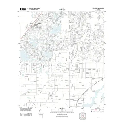
2012 Map of Port Richey NE
USGS Topo · Published 2012About this map
The dense suburban grid of Spring Hill is defined by its unique karst topography, where numerous ponds and sinkholes interrupt the residential street layout. Notable geological features like Willow Sink, Rock Sink, and Coffee Sink punctuate the landscape, serving as reminders of the area's porous limestone foundation. To the west, the residential developments of Weeki Wachee Acres and Weekiwachee Woodlands sit adjacent to Weekiwachee Prairie Lake, reflecting the rapid expansion of coastal communities in Hernando County. In the southeastern corner, the landscape remains more open near Crews Lake and Jumping Gully, providing a clear contrast to the high-density neighborhood planning seen elsewhere. Local historians can also find the Loyce Cemetery near the corridor of FL 589, documenting a quiet point of local genealogy amidst a modernizing suburban environment.
Find a feature on this map
19 named features on this map. Tap any name to fly to it.
Don’t see what you’re looking for? This feature index may not catch every label — zoom into the map to look around manually.
Map Details
Editions of this 2012 Port Richey NE Map
This is the sole edition of this map. No revisions or reprints were ever made.
Other maps of this area

1954 · Ehren
USGS Topo · 1:24,000

1954 · Port Richey
USGS Topo · 1:24,000

1954 · Fivay
USGS Topo · 1:24,000

1954 · Brooksville
USGS Topo · 1:24,000

1954 · Aripeka
USGS Topo · 1:24,000

1954 · Bayport
USGS Topo · 1:24,000

1954 · Masaryktown
USGS Topo · 1:24,000

1954 · Weekiwachee Springs
USGS Topo · 1:24,000

1954 · Port Richey NE
USGS Topo · 1:24,000

1955 · Plant City
USGS Topo · 1:250,000