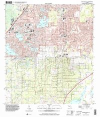
1999 Map of Port Richey NE
USGS Topo · Published 2002About this map
The boundary between Hernando and Pasco counties bisects a landscape defined by significant hydrological features and rapid late-century residential development. The northern portion of the map is dominated by the sprawling suburban expansion around Springstead High School and Deltona Elementary Sch, where numerous schools and residential blocks have integrated with natural features like Weekiwachee Prairie Lake. To the south, the terrain becomes more characterized by natural sinks and isolated water bodies, including Rock Sink, Coffee Sink, and the extensive Crews Lake.
Find a feature on this map
24 named features on this map. Tap any name to fly to it.
Don’t see what you’re looking for? This feature index may not catch every label — zoom into the map to look around manually.
Map Details
Editions of this 1999 Port Richey NE Map
This is the sole edition of this map. No revisions or reprints were ever made.
Other maps of this area

1954 · Ehren
USGS Topo · 1:24,000

1954 · Port Richey
USGS Topo · 1:24,000

1954 · Fivay
USGS Topo · 1:24,000

1954 · Brooksville
USGS Topo · 1:24,000

1954 · Aripeka
USGS Topo · 1:24,000

1954 · Bayport
USGS Topo · 1:24,000

1954 · Masaryktown
USGS Topo · 1:24,000

1954 · Weekiwachee Springs
USGS Topo · 1:24,000

1954 · Port Richey NE
USGS Topo · 1:24,000

1955 · Plant City
USGS Topo · 1:250,000