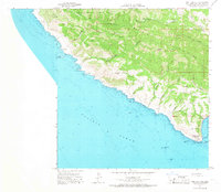
1965 Map of Port San Luis
USGS Topo · Published 1966About this map
The Irish Hills dominate this coastal landscape of San Luis Obispo County, where steep canyons like Ruda Canyon and Diablo Canyon cut through the mountains toward the Pacific Ocean. At the northern edge, Montana De Oro State Park encompasses the settlement at Spooner and the drainage of Coon Creek. The coastline is marked by jagged seafaring hazards including Lion Rock, Double Rock, and the Santa Rosa Reef, reflecting the maritime importance of this stretch of the Central Coast.
Find a feature on this map
47 named features on this map. Tap any name to fly to it.
Don’t see what you’re looking for? This feature index may not catch every label — zoom into the map to look around manually.
Map Details
Editions of this 1965 Port San Luis Map
3 editions found
Other maps of this area

1897 · Port Harford
USGS Topo · 1:62,500

1897 · San Luis Obispo
USGS Topo · 1:62,500

1897 · Cayucos
USGS Topo · 1:62,500

1897 · Arroyo Grande
USGS Topo · 1:62,500

1900 · San Luis
USGS Topo · 1:125,000

1937 · Cayucos
USGS Topo · 1:62,500

1941 · Port San Luis
USGS Topo · 1:62,500

1942 · San Luis Obispo
USGS Topo · 1:62,500

1942 · Arroyo Grande
USGS Topo · 1:62,500

1943 · Cayucos
USGS Topo · 1:62,500