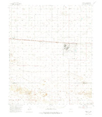
1957 Map of Portair
USGS Topo · Published 1976About this map
Cannon Air Force Base dominates the central landscape of this High Plains survey, reflecting the military expansion of the mid-century era. The surrounding agricultural terrain is etched by the tracks of the Atchison Topeka and Santa Fe railroad, which links a series of small trackside settlements including St Vrain, Grier, and the namesake station of Portair. These locations served as critical transit points for local goods and ranching supplies across the high desert flats.
Find a feature on this map
11 named features on this map. Tap any name to fly to it.
Don’t see what you’re looking for? This feature index may not catch every label — zoom into the map to look around manually.
Map Details
Editions of this 1957 Portair Map
2 editions found
Other maps of this area

1954 · Clovis
USGS Topo · 1:250,000

1957 · Portair
USGS Topo · 1:62,500

1957 · Melrose
USGS Topo · 1:62,500

1957 · Clovis
USGS Topo · 1:62,500

1957 · Arch
USGS Topo · 1:62,500

1957 · Portales
USGS Topo · 1:62,500

1957 · Pleasant Hill
USGS Topo · 1:62,500

1957 · Hammond Ranch
USGS Topo · 1:62,500

1958 · Clovis
USGS Topo · 1:250,000

1972 · Melrose East
USGS Topo · 1:24,000