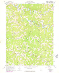
1960 Map of Porters Falls
USGS Topo · Published 1977About this map
Fishing Creek winds through a deeply incised landscape in this mid-century West Virginia survey, following a route shared by the Baltimore and Ohio railroad. The settlement pattern is defined by the valley floors and narrow ridges, with small communities like Minnie, Veto, and Porters Falls positioned along the water and rail corridor. Away from the creek, the high ground of New Martinsville Ridge and Hupp Ridge is dotted with numerous family-named landmarks and rural institutions, including the Wesley Chapel, Mt Zion Ch, and the Fluharty Cem.
Find a feature on this map
75 named features on this map. Tap any name to fly to it.
Don’t see what you’re looking for? This feature index may not catch every label — zoom into the map to look around manually.
Map Details
Editions of this 1960 Porters Falls Map
2 editions found
Other maps of this area

1903 · Littleton
USGS Topo · 1:62,500

1905 · Centerpoint
USGS Topo · 1:62,500

1905 · West Union
USGS Topo · 1:62,500

1905 · Littleton
USGS Topo · 1:62,500

1906 · New Martinsville
USGS Topo · 1:62,500

1924 · New Martinsville
USGS Topo · 1:62,500

1924 · Centerpoint
USGS Topo · 1:62,500

1924 · Littleton
USGS Topo · 1:62,500

1924 · West Union
USGS Topo · 1:62,500

1925 · Centerpoint
USGS Topo · 1:62,500