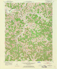
1952 Map of Portersburg
USGS Topo · Published 1970About this map
Small rural communities and a dense network of country schools define this section of Clay and Laurel Counties in the early 1950s. The Rockcastle River and its South Fork meander through the landscape, joined by numerous drainages like Mill Creek and Sandy Creek. The social fabric of the era is visible in the distribution of community hubs such as Portersburg, Fogertown, and McWhorter, many of which supported their own local educational and religious institutions. Notable examples include the Terrell Creek Sch, Dari Jones Sch, and New Salem Ch. The topography is marked by significant rises like Hammons Hill and Cutoff Mtn, while early industrial activity is evidenced by a Strip Mine located near Wyatt Chapel. This survey reflects a time before extensive modern development, when many families relied on these local landmarks and the winding mountain roads that connected them.
Find a feature on this map
62 named features on this map. Tap any name to fly to it.
Don’t see what you’re looking for? This feature index may not catch every label — zoom into the map to look around manually.
Map Details
Editions of this 1952 Portersburg Map
2 editions found
Other maps of this area

1891 · Manchester
USGS Topo · 1:125,000

1893 · London
USGS Topo · 1:125,000

1897 · London
USGS Topo · 1:125,000

1952 · Portersburg
USGS Topo · 1:24,000

1952 · Hima
USGS Topo · 1:24,000

1952 · Blackwater
USGS Topo · 1:24,000

1952 · Lily
USGS Topo · 1:24,000

1952 · Manchester
USGS Topo · 1:24,000

1952 · London
USGS Topo · 1:24,000

1953 · Tyner
USGS Topo · 1:24,000