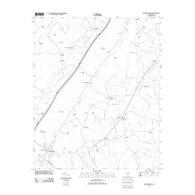
2011 Map of Portersville
USGS Topo · Published 2011About this map
Collinsville anchors the southern portion of this Alabama landscape, where the Collinsville Post Office and several burial grounds like Kerley Cemetery and Collins Cemetery serve as historical markers for the community. The terrain is defined by a series of prominent gaps and coves, including Portersville Gap, Wesson Gap, and Clayton Cove, which dictated the early movement and settlement patterns between Big Wills Creek and Mush Creek. Small rural centers such as Lebanon, Portersville, and Mount Vernon are linked by a network of county roads that navigate around landmarks like Drake Hill and Wooten Hill. For family historians, the presence of numerous small cemeteries such as Downer Cemetery, Killian Cemetery, and the Smith Chapel Cemetery near Smith Chapel provides vital geographic context for locating ancestral homesteads across the valley.
Find a feature on this map
61 named features on this map. Tap any name to fly to it.
Don’t see what you’re looking for? This feature index may not catch every label — zoom into the map to look around manually.
Map Details
Editions of this 2011 Portersville Map
This is the sole edition of this map. No revisions or reprints were ever made.
Other maps of this area

1893 · Fort Payne
USGS Topo · 1:125,000

1898 · Fort Payne
USGS Topo · 1:125,000

1900 · Fort Payne
USGS Topo · 1:125,000

1936 · Crossville
USGS Topo · 1:24,000

1936 · Roden Gap
USGS Topo · 1:24,000

1936 · Chavies
USGS Topo · 1:24,000
1936 · Fyffe
USGS Topo · 1:24,000

1946 · Portersville
USGS Topo · 1:24,000

1946 · Ft Payne
USGS Topo · 1:24,000
1946 · Chavies
USGS Topo · 1:24,000