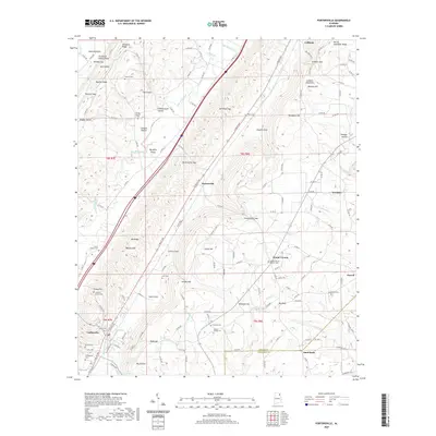
2020 Map of Portersville
USGS Topo · Published 2020About this map
Collinsville sits at the southwestern edge of this landscape where Big Wills Valley meets the high elevations of Lookout Mountain. This 2020 survey documents the complex topography of the DeKalb and Cherokee County border, defined by parallel ridges like Shinbone Ridge and Big Ridge. The historical settlement pattern is clearly visible through numerous family-named cemeteries and landmarks, including Anthony Collins Cem, Plunket Cem, and Downer Cem, suggesting deep genealogical roots in the hollows and gaps of the region.
Find a feature on this map
154 named features on this map. Tap any name to fly to it.
Don’t see what you’re looking for? This feature index may not catch every label — zoom into the map to look around manually.
Map Details
Editions of this 2020 Portersville Map
This is the sole edition of this map. No revisions or reprints were ever made.
Other maps of this area

1893 · Fort Payne
USGS Topo · 1:125,000

1898 · Fort Payne
USGS Topo · 1:125,000

1900 · Fort Payne
USGS Topo · 1:125,000

1936 · Crossville
USGS Topo · 1:24,000

1936 · Roden Gap
USGS Topo · 1:24,000

1936 · Chavies
USGS Topo · 1:24,000
1936 · Fyffe
USGS Topo · 1:24,000

1946 · Portersville
USGS Topo · 1:24,000

1946 · Ft Payne
USGS Topo · 1:24,000
1946 · Chavies
USGS Topo · 1:24,000