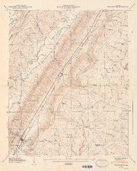
1947 Map of Portersville
USGS Topo · Published 1947About this map
Big Wills Valley serves as the central corridor for this 1946 field study, where the Southern railroad line links rural communities between the heights of Sand Mountain and Lookout Mountain. The settlement of Collinsville anchors the southwest corner, featuring a local reservoir and the Collinsville Cem, while Portersville sits at a critical gap in the ridge. The landscape is defined by its numerous small-scale religious and educational landmarks, such as Graham Chapel, Smith Chapel, and the Brown Fell Sch. Local industry and family history are evident in features like Longshore Mill and the dispersed burial grounds including Paley Cem and Plunket Cem. The complex topography of Shinbone Ridge and Little Wills Valley illustrates a mid-century Alabama landscape still oriented around its natural gaps and creek drainage systems like Mush Creek and Yellow Creek.
Find a feature on this map
68 named features on this map. Tap any name to fly to it.
Don’t see what you’re looking for? This feature index may not catch every label — zoom into the map to look around manually.
Map Details
Editions of this 1947 Portersville Map
2 editions found
Other maps of this area

1893 · Fort Payne
USGS Topo · 1:125,000

1898 · Fort Payne
USGS Topo · 1:125,000

1900 · Fort Payne
USGS Topo · 1:125,000

1936 · Crossville
USGS Topo · 1:24,000

1936 · Roden Gap
USGS Topo · 1:24,000

1936 · Chavies
USGS Topo · 1:24,000
1936 · Fyffe
USGS Topo · 1:24,000

1946 · Portersville
USGS Topo · 1:24,000

1946 · Ft Payne
USGS Topo · 1:24,000
1946 · Chavies
USGS Topo · 1:24,000