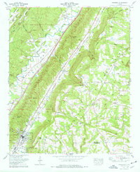
1975 Map of Portersville
USGS Topo · Published 1977About this map
Big Wills Valley and Little Wills Valley dominate this landscape, separated by the prominent Shinbone Ridge. In the mid-1970s, the community of Collinsville serves as a local hub at the southern end of the quadrangle, featuring a High Sch, National Guard Armory, and multiple churches. The presence of numerous family-named cemeteries, such as the Warren-Stewart Cem, Anthony Collins Cem, and Plunket Cem, provides significant value for genealogical research in this corridor of northeast Alabama.
Find a feature on this map
76 named features on this map. Tap any name to fly to it.
Don’t see what you’re looking for? This feature index may not catch every label — zoom into the map to look around manually.
Map Details
Editions of this 1975 Portersville Map
2 editions found
Other maps of this area

1893 · Fort Payne
USGS Topo · 1:125,000

1898 · Fort Payne
USGS Topo · 1:125,000

1900 · Fort Payne
USGS Topo · 1:125,000

1936 · Crossville
USGS Topo · 1:24,000

1936 · Roden Gap
USGS Topo · 1:24,000

1936 · Chavies
USGS Topo · 1:24,000
1936 · Fyffe
USGS Topo · 1:24,000

1946 · Portersville
USGS Topo · 1:24,000

1946 · Ft Payne
USGS Topo · 1:24,000
1946 · Chavies
USGS Topo · 1:24,000