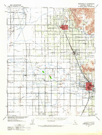
1942 Map of Porterville
USGS Topo · Published 1964About this map
Porterville and the agricultural lands of the San Joaquin Valley appear in this early wartime survey, defined by a rigid grid of avenues and irrigation canals. The drainage of the Tule River and its associated waterways, including Porter Slough and Mitchell Slough, dominate the low-lying terrain. To the northeast, the topography shifts abruptly as the valley floor meets the foothills at Elephant Back and Lindsay Peak. The map reveals a high density of rural schoolhouses, such as Vandalia Sch, Rockford Sch, and Prairie Center Sch, indicating a well-distributed population connected by the Southern Pacific and Atchison Topeka And Santa Fe railroads. The settlement pattern follows these rail lines closely, with towns like Lindsay, Strathmore, and Lois serving as focal points for the surrounding citrus and fruit-growing region. This 1942 snapshot captures the landscape before the massive post-war expansion, preserving the locations of smaller clusters like Woodville Community and Cairns Corner.
Find a feature on this map
59 named features on this map. Tap any name to fly to it.
Don’t see what you’re looking for? This feature index may not catch every label — zoom into the map to look around manually.
Map Details
Editions of this 1942 Porterville Map
2 editions found
Other maps of this area

1904 · Kaweah
USGS Topo · 1:125,000

1909 · Kaweah
USGS Topo · 1:125,000

1925 · Rocky Hill
USGS Topo · 1:31,680

1925 · Tulare
USGS Topo · 1:31,680

1925 · Tipton
USGS Topo · 1:31,680

1926 · Exeter
USGS Topo · 1:31,680

1927 · Cairns Corner
USGS Topo · 1:31,680

1927 · Rocky Hill
USGS Topo · 1:31,680

1927 · Visalia
USGS Topo · 1:31,680

1927 · Tulare
USGS Topo · 1:31,680