1897 Map of Portland
USGS Topo · Published 1901About this map
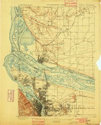
The Columbia River and Willamette River confluence defines this late-nineteenth-century landscape, capturing a pivotal era of regional growth and river-based industry. To the north, Vancouver is anchored by the historic Vancouver Barracks, while across the water, the growing street grid of St. John and the campus of Portland University at University Park mark the northward expansion of the metropolitan area. The intricate network of waterways including Columbia Slough, Smith Lake, and Bybee Lake illustrates a complex riparian environment before modern flood control and industrial development reshaped the riverfront. Rail infrastructure is well-established, with the Northern Pacific Railroad and the Oregon Railroad and Navigation lines threading through the river valleys. Prominent landmarks such as Mt. Tabor, Rocky Butte, and the then-distinct Guild Lake provide a clear topographic picture of the area's natural profile.
Find a feature on this map
67 named features on this map. Tap any name to fly to it.
Don’t see what you’re looking for? This feature index may not catch every label — zoom into the map to look around manually.
Map Details
Editions of this 1897 Portland Map
2 editions found
Other maps of this area

1897 · Portland
USGS Topo · 1:62,500

1905 · Portland
USGS Topo · 1:62,500

1911 · Boring
USGS Topo · 1:48,000

1914 · Boring
USGS Topo · 1:62,500

1914 · Oregon City
USGS Topo · 1:62,500

1915 · Hillsboro
USGS Topo · 1:62,500

1916 · Tualatin
USGS Topo · 1:62,500

1916 · Estacada
USGS Topo · 1:125,000

1918 · Hillsboro
USGS Topo · 1:62,500

1918 · Troutdale
USGS Topo · 1:62,500