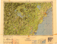
1949 Map of Portland
USGS Topo · Published 1950About this map
Portland and its bustling harbor serve as the focal point of this regional study, which captures the post-war transportation network of northern New England. The coastal reach from Saco Bay up to Casco Bay is defined by a dense concentration of maritime defenses and navigation aids, including Fort Williams, Fort Preble, and the iconic Portland Head Lighthouse. Inland, the landscape shifts from the industrial centers of Biddeford and Saco to the recreational waters of Sebago Lake and the massive Lake Winnipesaukee. The dominance of the Boston and Maine RR and the Maine Central RR illustrates the era's reliance on rail to connect the granite-peaked White Mountains with the Atlantic shoreline. This compilation provides a clear view of the region's topography before the full expansion of the interstate system, showing the early Maine Turnpike alongside established federal routes like U.S. Highway 1.
Find a feature on this map
308 named features on this map. Tap any name to fly to it.
Don’t see what you’re looking for? This feature index may not catch every label — zoom into the map to look around manually.
Map Details
Editions of this 1949 Portland Map
3 editions found

Other maps of this area

1888 · Newburyport
USGS Topo · 1:62,500

1888 · Haverhill
USGS Topo · 1:62,500

1890 · Haverhill
USGS Topo · 1:62,500

1890 · Newburyport
USGS Topo · 1:62,500

1891 · Portland
USGS Topo · 1:62,500

1891 · Biddeford
USGS Topo · 1:62,500

1891 · Berwick
USGS Topo · 1:62,500

1891 · Kennebunk
USGS Topo · 1:62,500

1891 · Buxton
USGS Topo · 1:62,500

1891 · Newfield
USGS Topo · 1:62,500