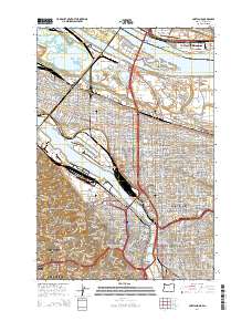
2014 Map of Portland
USGS Topo · Published 2014About this map
Portland and Vancouver are tied together by a complex network of bridges crossing the Columbia River and Willamette River in this 2014 survey. The map details the dense urban infrastructure of the Pacific Northwest, showcasing the massive BNSF Railway yards and the numerous spans that define the cityscape, including the Fremont Bridge, Steel Bridge, and Marquam Bridge. The industrial waterfronts around Swan Island and Mocks Bottom contrast with the established residential character of neighborhoods like Irvington, Alameda, and Laurelhurst.
Find a feature on this map
104 named features on this map. Tap any name to fly to it.
Don’t see what you’re looking for? This feature index may not catch every label — zoom into the map to look around manually.
Map Details
Editions of this 2014 Portland Map
This is the sole edition of this map. No revisions or reprints were ever made.
Other maps of this area

1897 · Portland
USGS Topo · 1:62,500

1905 · Portland
USGS Topo · 1:62,500

1914 · Oregon City
USGS Topo · 1:62,500

1915 · Hillsboro
USGS Topo · 1:62,500

1916 · Tualatin
USGS Topo · 1:62,500

1918 · Hillsboro
USGS Topo · 1:62,500

1939 · Oregon City
USGS Topo · 1:62,500

1939 · Tualatin
USGS Topo · 1:62,500

1940 · Tualatin
USGS Topo · 1:62,500

1940 · Hillsboro
USGS Topo · 1:62,500