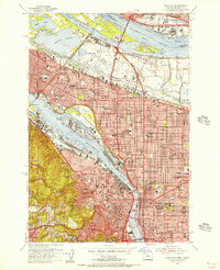
1954 Map of Portland
USGS Topo · Published 1956About this map
Vanport City (Site) occupies a prominent position on this mid-1950s survey, representing the aftermath of the 1948 flood that destroyed what was once the largest housing project in the nation. The industrial landscape is anchored by the Swan Island Shipyard and the Port of Portland, emphasizing the city's role as a post-war maritime and logistical hub. To the north, Hayden Island and the Columbia River facilitate commerce between Oregon and Washington, where Fort Vancouver Natl Monument and Pearson Airpark sit just across the border. Within the city proper, established neighborhoods like St Johns, Albina, and Irvington are densely detailed alongside educational institutions like the University of Portland and Reed College. The map captures a moment of infrastructure growth, showing the rail networks of the Union Pacific and Spokane Portland & Seattle intersecting with developing thoroughfares like the Pacific Highway.
Find a feature on this map
143 named features on this map. Tap any name to fly to it.
Don’t see what you’re looking for? This feature index may not catch every label — zoom into the map to look around manually.
Map Details
Editions of this 1954 Portland Map
This is the sole edition of this map. No revisions or reprints were ever made.
Other maps of this area

1897 · Portland
USGS Topo · 1:62,500

1905 · Portland
USGS Topo · 1:62,500

1914 · Oregon City
USGS Topo · 1:62,500

1915 · Hillsboro
USGS Topo · 1:62,500

1916 · Tualatin
USGS Topo · 1:62,500

1918 · Hillsboro
USGS Topo · 1:62,500

1939 · Oregon City
USGS Topo · 1:62,500

1939 · Tualatin
USGS Topo · 1:62,500

1940 · Tualatin
USGS Topo · 1:62,500

1940 · Hillsboro
USGS Topo · 1:62,500