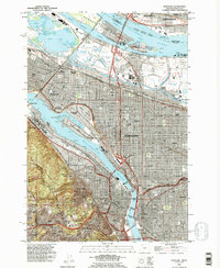
1990 Map of Portland
USGS Topo · Published 1995About this map
The Willamette River and Columbia River converge in this detailed mapping of the urban core and industrial waterfront during the final decade of the 20th century. The intricate transport network of Portland and Vancouver is defined by a series of landmark spans, including the Steel Bridge, Burnside Bridge, and the Morrison Bridge. Significant genealogical and institutional landmarks appear throughout the grid, from the historic Lone Fir Cemetery in East Portland to the campuses of Concordia College and the University of Portland.
Find a feature on this map
79 named features on this map. Tap any name to fly to it.
Don’t see what you’re looking for? This feature index may not catch every label — zoom into the map to look around manually.
Map Details
Editions of this 1990 Portland Map
This is the sole edition of this map. No revisions or reprints were ever made.
Other maps of this area

1897 · Portland
USGS Topo · 1:62,500

1905 · Portland
USGS Topo · 1:62,500

1914 · Oregon City
USGS Topo · 1:62,500

1915 · Hillsboro
USGS Topo · 1:62,500

1916 · Tualatin
USGS Topo · 1:62,500

1918 · Hillsboro
USGS Topo · 1:62,500

1939 · Oregon City
USGS Topo · 1:62,500

1939 · Tualatin
USGS Topo · 1:62,500

1940 · Tualatin
USGS Topo · 1:62,500

1940 · Hillsboro
USGS Topo · 1:62,500