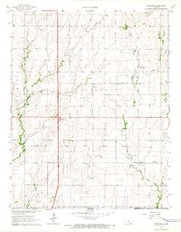
1965 Map of Portland
USGS Topo · Published 1968About this map
Portland sits at the intersection of heavy rail and emerging modern highways in this mid-1960s snapshot of Sumner County. The landscape is defined by a significant energy infrastructure, including the Portland Oil Field, Guelph Oil Field, and Bitter Creek Oil Field, which pockmark the prairie alongside agricultural fields. Running east-to-west, the Atchison Topeka and Santa Fe railroad provides a traditional transport spine, while the north-south Kansas Turnpike with its South Haven Interchange signals the era's shift toward high-speed interstate travel.
Find a feature on this map
21 named features on this map. Tap any name to fly to it.
Don’t see what you’re looking for? This feature index may not catch every label — zoom into the map to look around manually.
Map Details
Editions of this 1965 Portland Map
2 editions found
Other maps of this area

1890 · Wellington
USGS Topo · 1:125,000

1955 · Wichita
USGS Topo · 1:250,000

1955 · Enid
USGS Topo · 1:250,000

1958 · Enid
USGS Topo · 1:250,000

1958 · Wichita
USGS Topo · 1:250,000

1964 · South Haven NE
USGS Topo · 1:24,000

1965 · Portland
USGS Topo · 1:24,000

1965 · Adamsville
USGS Topo · 1:24,000

1965 · South Haven
USGS Topo · 1:24,000

1965 · Geuda Springs
USGS Topo · 1:24,000