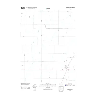
2013 Map of Portsmouth
USGS Topo · Published 2013About this map
Portsmouth sits at a crossroads in the southeastern corner of this Shelby County landscape, where the local road grid meets the winding course of Mosquito Cr. The area is defined by a dense network of drainage, with Pigeon Cr and its various tributaries, including Little Pigeon Cr and Picayune Cr, carving through the agricultural terrain. The map reveals the meticulous 2013-era section lines and rural addresses, such as Vienna Ave and Troy Trl, which dictate the movement of people and commerce across the plains. These corridors connect isolated farmsteads to the central hub of Portsmouth, providing a clear record of the modern rural settlement pattern and the persistent influence of the local creek systems on property and road placement.
Find a feature on this map
50 named features on this map. Tap any name to fly to it.
Don’t see what you’re looking for? This feature index may not catch every label — zoom into the map to look around manually.
Map Details
Editions of this 2013 Portsmouth Map
This is the sole edition of this map. No revisions or reprints were ever made.
Other maps of this area

1954 · Omaha
USGS Topo · 1:250,000

1957 · Omaha
USGS Topo · 1:250,000

1958 · Omaha
USGS Topo · 1:250,000

1971 · Earling
USGS Topo · 1:24,000

1971 · Dunlap SW
USGS Topo · 1:24,000

1971 · Dunlap
USGS Topo · 1:24,000
1978 · Hard Scratch
USGS Topo · 1:24,000

1978 · Panama
USGS Topo · 1:24,000

1978 · Persia
USGS Topo · 1:24,000
1978 · Woodbine
USGS Topo · 1:24,000