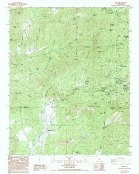
1986 Map of Posey
USGS Topo · Published 1994About this map
Posey serves as a central point in this high-altitude landscape where the southern reaches of the Sequoia National Forest meet the Tulare and Kern County line. The topography is defined by the Linns Valley and numerous steep drainages such as Long Pine Canyon and Grassy Canyon. Human settlement is clustered in specialized enclaves like Sugarloaf Village, Panorama Heights, and the White River Summer Home Tract, reflecting the area's development as a seasonal retreat and ranching territory. Resource extraction and forest management are evident through the Tungstore Mine and the Poso Forest Service Sta, while private landholdings like Bowen Ranch and Burton Ranch indicate the enduring presence of large family estates. The transition from the Bald Hills to timbered peaks like King George Peak highlights a diverse environment managed for both recreation and utility, including a Pipeline and a dedicated Telephone line corridor.
Find a feature on this map
70 named features on this map. Tap any name to fly to it.
Don’t see what you’re looking for? This feature index may not catch every label — zoom into the map to look around manually.
Map Details
Editions of this 1986 Posey Map
2 editions found
Other maps of this area

1920 · Delonagha
USGS Topo · 1:62,500

1926 · Glennville
USGS Topo · 1:62,500

1932 · Woody
USGS Topo · 1:62,500

1935 · Woody
USGS Topo · 1:62,500

1936 · White River
USGS Topo · 1:62,500

1936 · Tobias Peak
USGS Topo · 1:125,000

1943 · Tobias Peak
USGS Topo · 1:125,000

1945 · Tobias Peak
USGS Topo · 1:62,500

1948 · Bakersfield
USGS Topo · 1:250,000
1952 · Woody
USGS Topo · 1:62,500