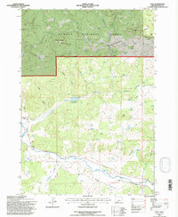
1992 Map of Post
USGS Topo · Published 1997About this map
The Crooked River carves a path through the southern half of this landscape, anchoring the settlement of Post in the high desert of central Oregon. This 1990s revision reveals a land defined by water management and ranching history, where the National Forest Boundary separates the lower river valley from the timbered heights of the Ochoco National Forest. High-elevation landmarks like Pollard Butte and the Ochoco Mountains dominate the northern terrain, while the lower country is marked by a network of drainage systems like Pringle Gulch and Newsome Creek. The presence of the Bonnieview Ranch and numerous Stock Ponds underscores the area's agricultural character, supported by vital water sources like the Horse Heaven Reservoir and Joe Butte Spring. This map offers a detailed view of the rugged transition from the forest's edge to the productive river bottomlands.
Find a feature on this map
33 named features on this map. Tap any name to fly to it.
Don’t see what you’re looking for? This feature index may not catch every label — zoom into the map to look around manually.
Map Details
Editions of this 1992 Post Map
This is the sole edition of this map. No revisions or reprints were ever made.
Other maps of this area

1946 · Eagle Rock
USGS Topo · 1:62,500

1948 · Eagle Rock
USGS Topo · 1:62,500

1948 · Ochoco Reservoir
USGS Topo · 1:62,500

1950 · Ochoco Reservoir
USGS Topo · 1:62,500

1951 · Post
USGS Topo · 1:62,500

1951 · Lookout Mtn
USGS Topo · 1:62,500

1955 · Bend
USGS Topo · 1:250,000

1957 · Bend
USGS Topo · 1:250,000

1958 · Bend
USGS Topo · 1:250,000

1981 · Prineville
USGS Topo · 1:100,000