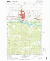
1981 Map of Post Falls
USGS Topo · Published 1982About this map
The Spokane River divides this Idaho landscape, separating the level agricultural and industrial lands of the Rathdrum Prairie from the steep, creek-cut slopes of Blossom Mountain. In the early 1980s, the community of Post Falls appears as a growing hub of residential and civic activity, centered around City Hall, the Post Office, and a series of schools including Seltice School and the local High School. The river itself is a site of utility and recreation, featuring a Powerhouse, a Gaging Station, and the waterfront River Park.
Find a feature on this map
51 named features on this map. Tap any name to fly to it.
Don’t see what you’re looking for? This feature index may not catch every label — zoom into the map to look around manually.
Map Details
Editions of this 1981 Post Falls Map
2 editions found
Other maps of this area

1901 · Spokane
USGS Topo · 1:125,000

1903 · Rathdrum
USGS Topo · 1:125,000

1943 · Mt Spokane
USGS Topo · 1:62,500

1949 · Greenacres
USGS Topo · 1:62,500

1950 · Mt Spokane
USGS Topo · 1:62,500

1951 · Greenacres
USGS Topo · 1:62,500

1955 · Spokane
USGS Topo · 1:250,000

1957 · Coeur D'Alene
USGS Topo · 1:62,500

1958 · Spokane
USGS Topo · 1:250,000

1961 · Hayden
USGS Topo · 1:24,000